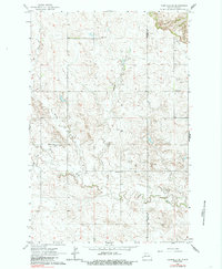
1963 Map of Fairfield SE
USGS Topo · Published 1985About this map
Ukrania Sch and the St Demetrius Cem anchor a landscape of high prairie and coulees at the border of Billings and Dunn counties. This mid-century survey captures a rural environment defined by isolated schoolhouses and religious landmarks, including the SS Peter and Paul Cem and Barta Sch. The terrain is deeply etched by a network of drainage systems, with the Green River winding through the southern portion of the quadrangle while Indian Creek and Horse Creek carve through the north. The presence of named rural schoolhouses like Hecker Sch and Willman Sch illustrates a period when small, localized education centers still served the widely dispersed farmsteads of the North Dakota badlands and surrounding plains.
Find a feature on this map
11 named features on this map. Tap any name to fly to it.
Don’t see what you’re looking for? This feature index may not catch every label — zoom into the map to look around manually.
Map Details
Editions of this 1963 Fairfield SE Map
2 editions found
Other maps of this area

1953 · Dickinson
USGS Topo · 1:250,000

1953 · Watford City
USGS Topo · 1:250,000

1957 · Dickinson
USGS Topo · 1:250,000

1957 · Watford City
USGS Topo · 1:250,000

1962 · Belfield NE
USGS Topo · 1:24,000

1962 · Belfield
USGS Topo · 1:24,000

1963 · Fairfield SE
USGS Topo · 1:24,000

1963 · Fairfield
USGS Topo · 1:24,000

1963 · Rattlesnake Butte
USGS Topo · 1:24,000

1963 · Hungry Man Butte
USGS Topo · 1:24,000