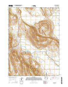
2014 Map of Dairy
USGS Topo · Published 2014About this map
Dairy sits at the junction of Or-140 and Or-70, serving as a central point in this high-altitude ranching and agricultural landscape of Klamath County. The terrain is defined by dramatic topographical shifts, from the low-lying Yonna Valley and Poe Valley to the steep basalt elevations of Horton Rim and Modoc Ridge. Water management is central to the area's utility, with the Lost River feeding an intricate system of irrigation canals including B Canal, F Canal, and the G Lateral.
Find a feature on this map
36 named features on this map. Tap any name to fly to it.
Don’t see what you’re looking for? This feature index may not catch every label — zoom into the map to look around manually.
Map Details
Editions of this 2014 Dairy Map
This is the sole edition of this map. No revisions or reprints were ever made.
Other maps of this area

1889 · Klamath
USGS Topo · 1:250,000

1894 · Klamath
USGS Topo · 1:250,000

1955 · Klamath Falls
USGS Topo · 1:250,000

1957 · Merrill
USGS Topo · 1:62,500

1957 · Swan Lake
USGS Topo · 1:62,500

1957 · Malin
USGS Topo · 1:62,500

1958 · Klamath Falls
USGS Topo · 1:250,000

1960 · Beatty
USGS Topo · 1:62,500

1975 · Merrill NW
USGS Topo · 1:24,000
1985 · Dairy
USGS Topo · 1:24,000