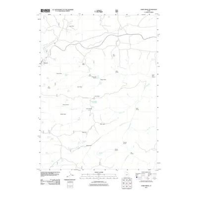
2011 Map of Dairy Ridge
USGS Topo · Published 2011About this map
Monte Cristo Campground serves as a central landmark in this high-elevation landscape of Weber County, where multiple ridges and hollows converge. The terrain is defined by prominent elevations like Eccles Peak and Baldy Peak, while the watershed is marked by the presence of Dairy Ridge Reservoir and numerous named springs such as Limestone Spring and Phosphate Spring. The drainage patterns are clearly delineated by Birch Creek, Wheeler Creek, and Woodruff Creek, which flow through various named hollows including Zeke Hollow and Peggy Hollow.
Find a feature on this map
59 named features on this map. Tap any name to fly to it.
Don’t see what you’re looking for? This feature index may not catch every label — zoom into the map to look around manually.
Map Details
Editions of this 2011 Dairy Ridge Map
This is the sole edition of this map. No revisions or reprints were ever made.
Other maps of this area

1912 · Randolph
USGS Topo · 1:125,000

1914 · Logan
USGS Topo · 1:125,000

1916 · Logan
USGS Topo · 1:125,000

1954 · Ogden
USGS Topo · 1:250,000

1958 · Ogden
USGS Topo · 1:250,000

1960 · Ogden
USGS Topo · 1:250,000

1964 · Monte Cristo PK
USGS Topo · 1:24,000
1964 · Causey Dam
USGS Topo · 1:24,000

1968 · Horse Ridge
USGS Topo · 1:24,000

1968 · Dairy Ridge
USGS Topo · 1:24,000