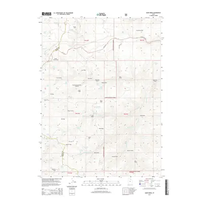
2014 Map of Dairy Ridge
USGS Topo · Published 2014About this map
Eccles Peak and the Monte Cristo Range dominate this high-altitude landscape within the Cache National Forest along the borders of Weber, Cache, and Rich Counties. The terrain is defined by a series of prominent ridges and hollows, including Strawberry Ridge, Baldy Ridge, and Eli Ridge. Water sources are numerous and vital in this environment, represented by a high density of named springs such as Davenport Spring, Freds Spring, and Wheeler Spring. At the center of the sheet, the Dairy Ridge Reservoir collects runoff from the surrounding peaks. The human footprint is focused on transportation and water management, with State Hwy 39 and W Monte Cristo Rd providing access through the canyons. This map is a record of the intricate watershed management in the Utah high country, tracing the beginnings of Woodruff Cr and Wheeler Cr.
Find a feature on this map
73 named features on this map. Tap any name to fly to it.
Don’t see what you’re looking for? This feature index may not catch every label — zoom into the map to look around manually.
Map Details
Editions of this 2014 Dairy Ridge Map
This is the sole edition of this map. No revisions or reprints were ever made.
Other maps of this area

1912 · Randolph
USGS Topo · 1:125,000

1914 · Logan
USGS Topo · 1:125,000

1916 · Logan
USGS Topo · 1:125,000

1954 · Ogden
USGS Topo · 1:250,000

1958 · Ogden
USGS Topo · 1:250,000

1960 · Ogden
USGS Topo · 1:250,000

1964 · Monte Cristo PK
USGS Topo · 1:24,000
1964 · Causey Dam
USGS Topo · 1:24,000

1968 · Horse Ridge
USGS Topo · 1:24,000

1968 · Dairy Ridge
USGS Topo · 1:24,000