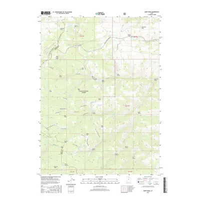
2017 Map of Dairy Ridge
USGS Topo · Published 2017About this map
Eccles Peak and the high elevations of the Monte Cristo Range dominate this corner of the Cache National Forest, where the borders of Cache, Rich, and Weber counties meet. This 2017 survey shows a landscape defined by seasonal access and high-altitude water management, centered around the Dairy Ridge Reservoir and the headwaters of Wheeler Cr and Woodruff Cr. The complex terrain is etched with numerous named hollows and ridges, including Strawberry Ridge and Baldy Ridge, which are traversed by the Silvia Powerline and a network of specialized routes like the Curtis Creek Snowmobile trail. Historical land use is evident in the naming of Sawmill Canyon and Girl Hollow, while dozens of natural water sources like Davenport Spring and Hatch Spring illustrate the hydrological importance of this montane environment for the surrounding region.
Find a feature on this map
87 named features on this map. Tap any name to fly to it.
Don’t see what you’re looking for? This feature index may not catch every label — zoom into the map to look around manually.
Map Details
Editions of this 2017 Dairy Ridge Map
This is the sole edition of this map. No revisions or reprints were ever made.
Other maps of this area

1912 · Randolph
USGS Topo · 1:125,000

1914 · Logan
USGS Topo · 1:125,000

1916 · Logan
USGS Topo · 1:125,000

1954 · Ogden
USGS Topo · 1:250,000

1958 · Ogden
USGS Topo · 1:250,000

1960 · Ogden
USGS Topo · 1:250,000

1964 · Monte Cristo PK
USGS Topo · 1:24,000
1964 · Causey Dam
USGS Topo · 1:24,000

1968 · Horse Ridge
USGS Topo · 1:24,000

1968 · Dairy Ridge
USGS Topo · 1:24,000