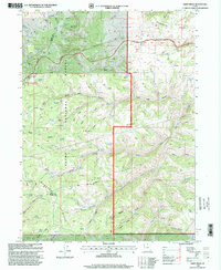
1998 Map of Dairy Ridge
USGS Topo · Published 2001About this map
Dairy Ridge serves as the central high-ground spine of this survey, where the boundaries of Rich, Weber, and Cache counties converge. The high-altitude terrain is defined by the intersection of the Cache National Forest and Wasatch National Forest, characterized by a complex network of seasonal drainages and springs such as Neponset Spring and Bountiful Spring. Human activity is concentrated near the western edge at the Monte Cristo Campground and the Monte Cristo Guard Sta, while the eastern slopes fall away toward Woodruff Canyon. The inclusion of various labeled Prospect sites and the isolated Dairy Ridge Reservoir suggests a landscape utilized for both resource extraction and high-country grazing during the late twentieth century. A prominent Scenic Byway traverses the northern reaches, following Walton Canyon through the Strawberry Ridge area.
Find a feature on this map
72 named features on this map. Tap any name to fly to it.
Don’t see what you’re looking for? This feature index may not catch every label — zoom into the map to look around manually.
Map Details
Editions of this 1998 Dairy Ridge Map
This is the sole edition of this map. No revisions or reprints were ever made.
Other maps of this area

1912 · Randolph
USGS Topo · 1:125,000

1914 · Logan
USGS Topo · 1:125,000

1916 · Logan
USGS Topo · 1:125,000

1954 · Ogden
USGS Topo · 1:250,000

1958 · Ogden
USGS Topo · 1:250,000

1960 · Ogden
USGS Topo · 1:250,000

1964 · Monte Cristo PK
USGS Topo · 1:24,000
1964 · Causey Dam
USGS Topo · 1:24,000

1968 · Horse Ridge
USGS Topo · 1:24,000

1968 · Dairy Ridge
USGS Topo · 1:24,000