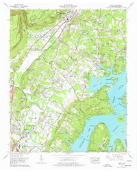
1976 Map of Daisy
USGS Topo · Published 1977About this map
Chickamauga Lake and the Tennessee River dominate the eastern landscape of this 1970s survey, illustrating the significant residential expansion following the Tennessee Valley Authority’s mid-century water management projects. The map captures the suburbanization of Hamilton County, where established communities like Daisy and Hixson are joined by newer developments such as Middle Valley Estates and Lakeshore Estates. The area is geographically defined by the Cumberland Escarpment and Walden Ridge to the west, with the Southern Railway corridor following the valley floor near Dayton Pike. Local history is deeply embedded in the terrain, from the strip mine operations near Grasshopper Hill to numerous family burial grounds like Shadwick Cem and Walker Cem. The map reveals a transition from an industrial and agricultural past—evidenced by Greens Mill and Olde Mill—toward a recreation-oriented economy centered on Harrison Bay State Park and Dallas Bay Skypark.
Find a feature on this map
100 named features on this map. Tap any name to fly to it.
Don’t see what you’re looking for? This feature index may not catch every label — zoom into the map to look around manually.
Map Details
Editions of this 1976 Daisy Map
2 editions found
Other maps of this area

1888 · Chattanooga
USGS Topo · 1:125,000

1893 · Chattanooga
USGS Topo · 1:125,000

1935 · East Chattanooga
USGS Topo · 1:24,000

1935 · Daisy
USGS Topo · 1:24,000

1935 · Soddy
USGS Topo · 1:24,000

1935 · Snow Hill
USGS Topo · 1:24,000

1935 · Ooltewah
USGS Topo · 1:24,000

1935 · Soddy Island
USGS Topo · 1:24,000

1936 · Henson Gap
USGS Topo · 1:24,000

1936 · Fairmount
USGS Topo · 1:24,000