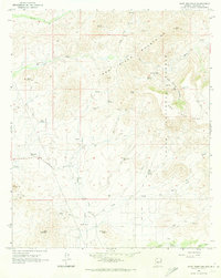
1964 Map of Daisy Mountain
USGS Topo · Published 1972About this map
Daisy Mountains dominate the landscape of north-central Arizona in this mid-1960s survey, where the New River carves a path through the northern high ground. The map details a period of transition between cattle ranching and early recreational or residential use, marked by features such as Tee Ranch and the Sharman Landing Strip. The presence of the Daisy Mine and various quarries indicates the area's mineral interests, while the Wranglers Roost points to the region's developing identity as a retreat or outpost.
Find a feature on this map
46 named features on this map. Tap any name to fly to it.
Don’t see what you’re looking for? This feature index may not catch every label — zoom into the map to look around manually.
Map Details
Editions of this 1964 Daisy Mountain Map
4 editions found
Other maps of this area

1887 · Verde
USGS Topo · 1:250,000

1887 · Prescott
USGS Topo · 1:250,000

1892 · Verde
USGS Topo · 1:250,000

1892 · Prescott
USGS Topo · 1:250,000

1903 · Bradshaw Mountains
USGS Topo · 1:125,000

1929 · Turret Peak
USGS Topo · 1:125,000

1930 · Cave Creek
USGS Topo · 1:125,000

1933 · Turret Peak
USGS Topo · 1:125,000

1939 · Cave Creek
USGS Topo · 1:125,000

1947 · Bumblebee
USGS Topo · 1:62,500