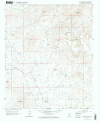
1964 Map of Daisy Mountain
USGS Topo · Published 1972About this map
Daisy Mountain and the New River Mountains anchor this arid landscape within the Tonto National Forest in the mid-1960s. The map captures a transition between high desert peaks and the water-dependent ranching and mining sites scattered throughout the rugged terrain. Local industry and activity are evident at the Daisy Mine, while several Ruins and the Sharman Landing Strip suggest changing land use over time. Grounded in a complex network of pack trails and jeep trails, the area relies heavily on remote water sources such as Moore Well, Skunk Creek, and the seasonally significant New River. Small outposts like Tee Ranch and Wranglers Roost stand as markers of human habitation in a region defined by its prominent landforms, including Gavilan Pk and the wide Mesa to the east.
Find a feature on this map
51 named features on this map. Tap any name to fly to it.
Don’t see what you’re looking for? This feature index may not catch every label — zoom into the map to look around manually.
Map Details
Editions of this 1964 Daisy Mountain Map
4 editions found
Other maps of this area

1887 · Verde
USGS Topo · 1:250,000

1887 · Prescott
USGS Topo · 1:250,000

1892 · Verde
USGS Topo · 1:250,000

1892 · Prescott
USGS Topo · 1:250,000

1903 · Bradshaw Mountains
USGS Topo · 1:125,000

1929 · Turret Peak
USGS Topo · 1:125,000

1930 · Cave Creek
USGS Topo · 1:125,000

1933 · Turret Peak
USGS Topo · 1:125,000

1939 · Cave Creek
USGS Topo · 1:125,000

1947 · Bumblebee
USGS Topo · 1:62,500