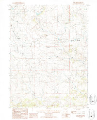
1987 Map of Dale Creek
USGS Topo · Published 1987About this map
The Union Pacific railroad corridor dominates this high-plains landscape in Albany County, where heavy infrastructure meets the historic path of the Overland Trail. This survey captures the complex engineering required to navigate the local drainage systems, specifically around the engineering landmark known as The Fill and the nearby Hermosa Tunnel. Small siding settlements and stops like Hermosa, Dale Creek, Woodard, and Johnson are scattered along the rail line, marking the functional anatomy of the transcontinental route during the late 20th century.
Find a feature on this map
27 named features on this map. Tap any name to fly to it.
Don’t see what you’re looking for? This feature index may not catch every label — zoom into the map to look around manually.
Map Details
Editions of this 1987 Dale Creek Map
This is the sole edition of this map. No revisions or reprints were ever made.
Other maps of this area

1895 · Laramie
USGS Topo · 1:125,000

1902 · Laramie
USGS Topo · 1:125,000

1905 · Sherman
USGS Topo · 1:125,000

1905 · Laramie
USGS Topo · 1:125,000

1906 · Laramie
USGS Topo · 1:125,000

1907 · Livermore
USGS Topo · 1:125,000

1908 · Laramie
USGS Topo · 1:125,000

1909 · Livermore
USGS Topo · 1:125,000

1916 · Home
USGS Topo · 1:125,000

1920 · Home
USGS Topo · 1:125,000