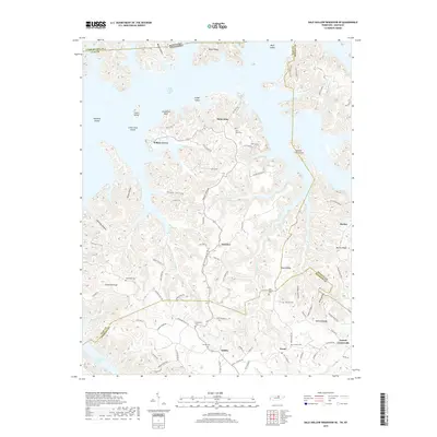
2019 Map of Dale Hollow Reservoir SE
USGS Topo · Published 2019About this map
Dale Hollow Lake dominates the upper reaches of this landscape, its complex shoreline winding around numerous islands and ridges at the meeting point of Clay, Pickett, and Overton Counties. The settlement of Willow Grove sits near the water's edge, while Saint John and Fairview occupy the higher ground to the east. The terrain is characterized by steep ridges and deep hollows, such as Hogan Hollow and Tipton Hollow, which have historically dictated the placement of mountain roads and small family farms. Numerous burial grounds, including Saint John Cem, Fellowship Cem, and Chowning Cem, are scattered throughout the hills, providing a window into the long-standing community ties of this rural highland region. In the south, Oakley and Ozone serve as interior crossroads, connected by a network of local roads that follow the winding paths of Ashburn Cr and Irons Cr.
Find a feature on this map
93 named features on this map. Tap any name to fly to it.
Don’t see what you’re looking for? This feature index may not catch every label — zoom into the map to look around manually.
Map Details
Editions of this 2019 Dale Hollow Reservoir SE Map
This is the sole edition of this map. No revisions or reprints were ever made.
Other maps of this area

1897 · Standingstone
USGS Topo · 1:125,000

1898 · Standingstone
USGS Topo · 1:125,000

1924 · Lillydale
USGS Topo · 1:62,500

1926 · Lillydale
USGS Topo · 1:62,500

1929 · Lillydale
USGS Topo · 1:62,500

1929 · Byrdstown
USGS Topo · 1:62,500

1944 · Livingston
USGS Topo · 1:24,000

1954 · Frogue
USGS Topo · 1:24,000

1954 · Blacks Ferry
USGS Topo · 1:24,000

1954 · Albany
USGS Topo · 1:24,000