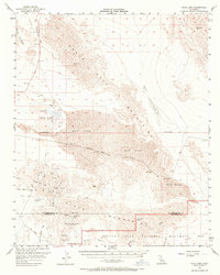
1956 Map of Dale Lake
USGS Topo · Published 1970About this map
Mining operations and industrial salt extraction dominate this arid landscape where the Pinto Mountains meet the Sheep Hole Mountains. The central basin is defined by the extensive Salt Evaporators of Dale Lake, supported by a network of Salt Wells and a Salt Pit near the settlement of Bush. To the south, the map reveals a dense concentration of hard-rock mining history, particularly around the New Dale location and the northern reaches of Joshua Tree National Monument.
Find a feature on this map
58 named features on this map. Tap any name to fly to it.
Don’t see what you’re looking for? This feature index may not catch every label — zoom into the map to look around manually.
Map Details
Editions of this 1956 Dale Lake Map
3 editions found

Other maps of this area

1942 · Amboy
USGS Topo · 1:250,000

1943 · Amboy
USGS Topo · 1:250,000

1943 · Cadiz Lake
USGS Topo · 1:62,500

1943 · Cadiz Valley
USGS Topo · 1:62,500

1943 · Coxcomb Mountains
USGS Topo · 1:62,500

1943 · Pinkham Well
USGS Topo · 1:62,500

1944 · Pinkham Well
USGS Topo · 1:62,500

1944 · Eagle Tank
USGS Topo · 1:62,500

1944 · Coxcomb Mountains
USGS Topo · 1:62,500

1954 · Salton Sea
USGS Topo · 1:250,000