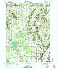
1949 Map of Dale
USGS Topo · Published 1984About this map
Attica Reservoir serves as a focal point in this Wyoming County landscape, where the waters of Stony Brook and Crow Creek cut through the high ground of the Genesee and Wyoming county border. The 1949 topography, based on 1942 aerial photography, reveals a rural economy organized around family-named corners and vital transit corridors like the Erie Railroad. Settlement patterns are distinctly concentrated at crossings such as Millers Crossing and Beehive Crossing, while the upland areas are marked by numerous small family and community burial grounds, including Brainard Cem, Hatch Cem, and Carlton Hill Cem. From the heights of Sulphur Spring Hill to the wetlands of Tamarack Swamp, the map documents a mid-century agricultural landscape defined by its specific geological features like Smith Gulf and Dersam Gulf.
Find a feature on this map
87 named features on this map. Tap any name to fly to it.
Don’t see what you’re looking for? This feature index may not catch every label — zoom into the map to look around manually.
Map Details
Editions of this 1949 Dale Map
3 editions found
Other maps of this area

1904 · Batavia
USGS Topo · 1:62,500

1905 · Attica
USGS Topo · 1:62,500

1905 · Portage
USGS Topo · 1:62,500

1923 · Arcade
USGS Topo · 1:62,500

1925 · Arcade
USGS Topo · 1:62,500

1943 · Warsaw
USGS Topo · 1:24,000

1943 · Castile
USGS Topo · 1:24,000

1944 · Alexander
USGS Topo · 1:31,680

1944 · Stafford
USGS Topo · 1:31,680

1944 · Warsaw
USGS Topo · 1:31,680