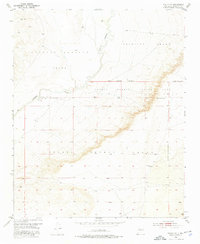
1952 Map of Dalies NW
USGS Topo · Published 1976About this map
Rio Puerco meanders through this arid landscape, carving a deep valley that serves as the primary drainage for several massive land grants. The territory is defined by the intersection of the Antonio Sedillo Grant, Pajarito Grant, and Isleta Pueblo Grant, reflecting the complex historical property boundaries of the region. Surveyed in 1952, the map illustrates a landscape of high mesas and shifting Sand dunes, where human activity is limited to remote infrastructure. A Community Well in the southeastern portion of the sheet provides a rare point of water in an otherwise dry expanse, while the New Mexico Principal Meridian serves as the foundational surveying line for the entire territory. This documentation captures the area before significant modern encroachment, preserving the original configurations of the Isleta Pueblo Indian Land.
Find a feature on this map
10 named features on this map. Tap any name to fly to it.
Don’t see what you’re looking for? This feature index may not catch every label — zoom into the map to look around manually.
Map Details
Editions of this 1952 Dalies NW Map
3 editions found

Other maps of this area

1883 · Mt. Taylor
USGS Topo · 1:250,000

1886 · Mt. Taylor
USGS Topo · 1:250,000

1888 · Bernalillo
USGS Topo · 1:125,000

1889 · Albuquerque
USGS Topo · 1:125,000

1892 · Mt. Taylor
USGS Topo · 1:250,000

1893 · Albuquerque
USGS Topo · 1:125,000

1899 · Mt. Taylor
USGS Topo · 1:250,000

1917 · Cerro Verde
USGS Topo · 1:125,000

1952 · Wind Mesa
USGS Topo · 1:24,000

1952 · Dalies
USGS Topo · 1:24,000