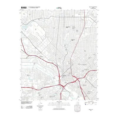
2010 Map of Dallas
USGS Topo · Published 2010About this map
Dallas and its northern enclaves of University Park and Highland Park are defined by a complex network of historic districts and transport infrastructure along the Trinity River corridor. The urban landscape is marked by numerous protected areas including the Swiss Avenue Historic District and the West End Historic District, reflecting the city's early 20th-century growth. Institutional anchors like Southern Methodist University and the University of Texas Southwestern Medical School occupy large footprints, while Dallas Love Field dominates the northwest quadrant. A legacy of early industry and civic development is evident in landmarks such as the Stanard Tilton Flour Mill and the Cotton Bowl. The map also reveals the city's funerary history through large sites like Greenwood Cemetery and Hillcrest Memorial Park, providing a detailed record of the metropolitan core as it functioned in the early 21st century.
Find a feature on this map
91 named features on this map. Tap any name to fly to it.
Don’t see what you’re looking for? This feature index may not catch every label — zoom into the map to look around manually.
Map Details
Editions of this 2010 Dallas Map
This is the sole edition of this map. No revisions or reprints were ever made.
Other maps of this area

1891 · Dallas
USGS Topo · 1:125,000

1893 · Dallas
USGS Topo · 1:125,000

1925 · Dallas 2-b
USGS Topo · 1:48,000

1931 · Carrollton
USGS Topo · 1:62,500

1954 · Dallas
USGS Topo · 1:250,000

1957 · White Rock Lake
USGS Topo · 1:24,000

1958 · Dallas
USGS Topo · 1:250,000

1958 · Hutchins
USGS Topo · 1:24,000

1958 · Oak Cliff
USGS Topo · 1:24,000

1958 · Dallas
USGS Topo · 1:24,000