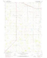
1964 Map of Dallas NW
USGS Topo · Published 1978About this map
Ponca Creek meanders through the northern reaches of this Tripp County landscape, defining the topography of the Pleasant View and Elliston townships. During the mid-1960s, this area remained primarily agricultural, anchored by community landmarks such as Calvary Chapel and the Kansas Flat Sch. The Chicago and North Western railroad cuts across the northeastern corner, providing a vital transport link for the rural economy.
Find a feature on this map
12 named features on this map. Tap any name to fly to it.
Don’t see what you’re looking for? This feature index may not catch every label — zoom into the map to look around manually.
Map Details
Editions of this 1964 Dallas NW Map
2 editions found
Other maps of this area

1955 · Mitchell
USGS Topo · 1:250,000

1959 · Mitchell
USGS Topo · 1:250,000

1964 · Dallas SW
USGS Topo · 1:24,000

1964 · Dallas
USGS Topo · 1:24,000

1964 · Paxton
USGS Topo · 1:24,000

1964 · Dallas NW
USGS Topo · 1:24,000

1971 · Colome
USGS Topo · 1:24,000

1971 · Colome SE
USGS Topo · 1:24,000
1982 · Wewela
USGS Topo · 1:24,000

1982 · Winner South
USGS Topo · 1:25,000