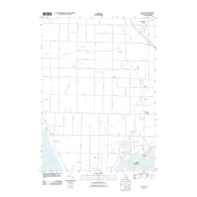
2011 Map of Dalton
USGS Topo · Published 2011About this map
North Muskegon sits at the southern edge of this 2011 survey, situated between the north shore of Muskegon Lake and the smaller Bear Lake. This area of Muskegon County shows a landscape defined by its coastal hydrology and industrial legacies, particularly the Laketon Oil Field located inland. The suburban and rural transition is marked by several cemeteries, including Fruitland Cemetery, Laketon Cemetery, and Bear Lake Cemetery, which provide stable points of reference for genealogists tracking family history in the Fruitland and Laketon townships. To the north, the small settlements of Dalton, Berry Junction, and Lakewood Club are connected by a grid of local roads like Whitehall Rd and Duck Lake Rd. Drainage is managed by several named waterways such as Duck Creek, Green Creek, and Todd Creek which flow toward the Lake Michigan shoreline, including the Birch Brook in the far northwest.
Find a feature on this map
81 named features on this map. Tap any name to fly to it.
Don’t see what you’re looking for? This feature index may not catch every label — zoom into the map to look around manually.
Map Details
Editions of this 2011 Dalton Map
This is the sole edition of this map. No revisions or reprints were ever made.
Other maps of this area

1929 · Montague
USGS Topo · 1:48,000

1930 · Lake Harbor
USGS Topo · 1:48,000

1930 · Muskegon
USGS Topo · 1:62,500

1936 · Muskegon
USGS Topo · 1:62,500

1936 · Lake Harbor
USGS Topo · 1:62,500

1954 · Milwaukee
USGS Topo · 1:250,000

1958 · Milwaukee
USGS Topo · 1:250,000

1958 · Twin Lake
USGS Topo · 1:62,500

1959 · Montague
USGS Topo · 1:62,500
1972 · Muskegon West
USGS Topo · 1:24,000