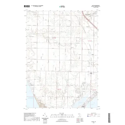
2019 Map of Dalton
USGS Topo · Published 2019About this map
Lake Michigan forms the western boundary of this coastal landscape, where the sandy shore transitions into a complex network of wetlands and small waterways. Inland, the town of North Muskegon sits prominently between Bear Lake and the larger Muskegon Lake, reflecting the region's historical orientation toward these deep-water access points. The map documents a blend of established residential areas and conserved corridors, most notably the Fred Meijer Berry Junction Trail, which follows an old rail alignment through Berry Junction. Small rural clusters like Lakewood Club and Dalton are scattered throughout the northern sections, separated by numerous small drainages such as Scholes Cr and Duck Cr. Local history is anchored by several burial grounds including Fruitland Cem and Laketon Cem, providing a record of the families that settled this area between the big lakes and the shoreline.
Find a feature on this map
100 named features on this map. Tap any name to fly to it.
Don’t see what you’re looking for? This feature index may not catch every label — zoom into the map to look around manually.
Map Details
Editions of this 2019 Dalton Map
This is the sole edition of this map. No revisions or reprints were ever made.
Other maps of this area

1929 · Montague
USGS Topo · 1:48,000

1930 · Lake Harbor
USGS Topo · 1:48,000

1930 · Muskegon
USGS Topo · 1:62,500

1936 · Muskegon
USGS Topo · 1:62,500

1936 · Lake Harbor
USGS Topo · 1:62,500

1954 · Milwaukee
USGS Topo · 1:250,000

1958 · Milwaukee
USGS Topo · 1:250,000

1958 · Twin Lake
USGS Topo · 1:62,500

1959 · Montague
USGS Topo · 1:62,500
1972 · Muskegon West
USGS Topo · 1:24,000