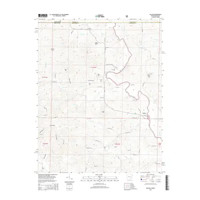
2014 Map of Dalton
USGS Topo · Published 2014About this map
Eleven Point River winds through this borderland region where the Missouri-Arkansas state line meets the boundary between Oregon and Randolph counties. The settlement of Dalton sits near the river's bend, while the community of Elm Store serves the northern reaches near Mill Cr. This landscape is deeply etched by history and geography, featuring prominent terrain such as Higgs Mtn and Nubbin Ridge.
Find a feature on this map
75 named features on this map. Tap any name to fly to it.
Don’t see what you’re looking for? This feature index may not catch every label — zoom into the map to look around manually.
Map Details
Editions of this 2014 Dalton Map
This is the sole edition of this map. No revisions or reprints were ever made.
Other maps of this area

1941 · Gatewood
USGS Topo · 1:62,500

1944 · Couch
USGS Topo · 1:62,500

1945 · Gatewood
USGS Topo · 1:62,500

1946 · Couch
USGS Topo · 1:62,500

1957 · Poplar Bluff
USGS Topo · 1:250,000

1959 · Poplar Bluff
USGS Topo · 1:250,000

1960 · Poplar Bluff
USGS Topo · 1:250,000

1965 · Gatewood
USGS Topo · 1:24,000

1966 · Ravenden Springs
USGS Topo · 1:24,000
1966 · Ravenden Springs SE
USGS Topo · 1:24,000