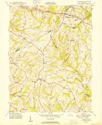
1950 Map of Damascus
USGS Topo · Published 1950About this map
Damascus sits at the high-elevation center of this 1950 Maryland survey, where the headwaters of several major drainage systems converge. The map documents the rural character of the region before late-twentieth-century suburbanization, showing a landscape defined by scattered agricultural settlements such as Kemptown, Browningsville, and Etchison. In the northern section, the Baltimore and Ohio RR cuts through the terrain near Mount Airy and Ridgeville, marking the vital rail corridor connecting the area to larger markets. The hydrology of the region is particularly detailed, tracing the origins of the Patuxent River and Great Seneca Creek, along with smaller tributaries like Bennett Creek and Fahrney Branch. This edition serves as a precise record of the road networks and farmsteads that once dominated the borders of Frederick, Carroll, Howard, and Montgomery Counties, including distinctive landmarks like the geological formation at Annapolis Rock.
Find a feature on this map
36 named features on this map. Tap any name to fly to it.
Don’t see what you’re looking for? This feature index may not catch every label — zoom into the map to look around manually.
Map Details
Editions of this 1950 Damascus Map
2 editions found
Other maps of this area

1893 · Frederick
USGS Topo · 1:125,000

1894 · Frederick
USGS Topo · 1:125,000

1908 · Rockville
USGS Topo · 1:62,500

1908 · Seneca
USGS Topo · 1:62,500

1908 · Ijamsville
USGS Topo · 1:62,500

1909 · Mount Airy
USGS Topo · 1:62,500

1909 · Ijamsville
USGS Topo · 1:62,500

1923 · Rockville
USGS Topo · 1:62,500

1942 · Frederick
USGS Topo · 1:62,500

1944 · Walkersville
USGS Topo · 1:31,680