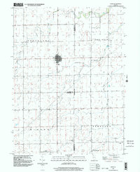
1999 Map of Dana
USGS Topo · Published 2003About this map
Dana sits at the convergence of several county lines in this central Illinois landscape, where the flat agricultural terrain is defined by its precise section boundaries and a network of small creeks. The village of Dana remains the primary settlement, situated near the Cem and just north of where the La Salle Co Woodford Co line meets Livingston Co. The rural character of the region is punctuated by scattered landmarks such as St Petri Ch and Bauman Cem in the southern portion of the quadrangle.
Find a feature on this map
19 named features on this map. Tap any name to fly to it.
Don’t see what you’re looking for? This feature index may not catch every label — zoom into the map to look around manually.
Map Details
Editions of this 1999 Dana Map
This is the sole edition of this map. No revisions or reprints were ever made.
Other maps of this area

1925 · Streator
USGS Topo · 1:62,500

1927 · Streator
USGS Topo · 1:62,500

1934 · Wenona
USGS Topo · 1:48,000

1939 · Wenona
USGS Topo · 1:62,500

1955 · Minonk
USGS Topo · 1:62,500

1958 · Flanagan
USGS Topo · 1:62,500

1958 · Aurora
USGS Topo · 1:250,000

1958 · Peoria
USGS Topo · 1:250,000

1961 · Aurora
USGS Topo · 1:250,000

1961 · Peoria
USGS Topo · 1:250,000