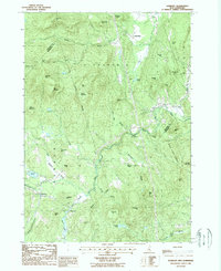
1987 Map of Danbury
USGS Topo · Published 1987About this map
The Smith River winds through this New Hampshire interior during the late 1980s, carving a valley that separates the rural settlements of Danbury and Alexandria. This region is defined by a dense network of family-named peaks and ridges, such as Forbes Mountain, The Pinnacle, and Alexander Hill, suggesting a long history of local land ownership and upland farming. The presence of multiple cemeteries marked simply as Cem underscores the deep roots of these small communities.
Find a feature on this map
54 named features on this map. Tap any name to fly to it.
Don’t see what you’re looking for? This feature index may not catch every label — zoom into the map to look around manually.
Map Details
Editions of this 1987 Danbury Map
This is the sole edition of this map. No revisions or reprints were ever made.
Other maps of this area

1925 · Holderness
USGS Topo · 1:62,500

1927 · Penacook
USGS Topo · 1:62,500

1927 · Holderness
USGS Topo · 1:62,500

1927 · Cardigan
USGS Topo · 1:62,500

1928 · Mount Kearsarge
USGS Topo · 1:62,500

1930 · Cardigan
USGS Topo · 1:62,500

1931 · Mount Kearsarge
USGS Topo · 1:62,500

1949 · Portland
USGS Topo · 1:250,000

1956 · Cardigan
USGS Topo · 1:62,500

1956 · Penacook
USGS Topo · 1:62,500