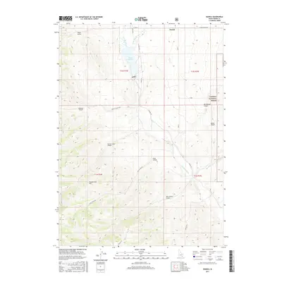
2017 Map of Daniels
USGS Topo · Published 2017About this map
Daniels and the surrounding high-desert terrain of Oneida County are defined by a network of drainage systems and family-named canyons feeding into the Little Malad River. This 2017 survey shows the agricultural and water management landscape of southeast Idaho, centered on the Daniels Reservoir which collects flow from Wright Cr and Hill Cr. The map preserves several local landmarks and lineage-linked names, such as Bill Morgan Canyon, Morgan Jones Canyon, and Danish Canyon, providing a clear record of land use and nomenclature. The eastern edge transition into the Caribou National Forest illustrates the boundary between managed private lands and federal wilderness, while the Pleasantview Hills dominate the southwestern reaches. Modern road systems like Daniels Rd and Sublette Canyon Rd trace the paths of older routes through the Sublette Canyon corridor.
Find a feature on this map
26 named features on this map. Tap any name to fly to it.
Don’t see what you’re looking for? This feature index may not catch every label — zoom into the map to look around manually.
Map Details
Editions of this 2017 Daniels Map
This is the sole edition of this map. No revisions or reprints were ever made.
Other maps of this area

1954 · Pocatello
USGS Topo · 1:250,000

1958 · Pocatello
USGS Topo · 1:250,000

1963 · Daniels
USGS Topo · 1:24,000

1968 · Ireland Springs
USGS Topo · 1:24,000

1968 · Daniels
USGS Topo · 1:24,000

1968 · Dairy Creek
USGS Topo · 1:24,000

1968 · Malad City West
USGS Topo · 1:24,000

1968 · Wakley Peak
USGS Topo · 1:24,000
1968 · Elkhorn Peak
USGS Topo · 1:24,000
1973 · Arbon
USGS Topo · 1:24,000