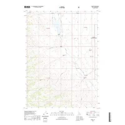
2020 Map of Daniels
USGS Topo · Published 2020About this map
Daniels sits at the northern edge of this high-elevation terrain, where the Little Malad River is impounded to form the Daniels Reservoir. The landscape is defined by deep drainages and ridges, including the Pleasantview Hills and the slopes of Mt Elkhorn. To the east, the boundary of the Caribou National Forest marks a transition into more heavily timbered land. A network of named canyons like Sublette Canyon, Morgan Jones Canyon, and Danish Canyon cut through the hills, illustrating how the topography dictated the path of early roads such as Daniels Rd and Point Canyon Rd. This survey shows the region's reliance on water management and grazing land, with numerous hollows and springs feeding into the central reservoir system.
Find a feature on this map
25 named features on this map. Tap any name to fly to it.
Don’t see what you’re looking for? This feature index may not catch every label — zoom into the map to look around manually.
Map Details
Editions of this 2020 Daniels Map
This is the sole edition of this map. No revisions or reprints were ever made.
Other maps of this area

1954 · Pocatello
USGS Topo · 1:250,000

1958 · Pocatello
USGS Topo · 1:250,000

1963 · Daniels
USGS Topo · 1:24,000

1968 · Ireland Springs
USGS Topo · 1:24,000

1968 · Daniels
USGS Topo · 1:24,000

1968 · Dairy Creek
USGS Topo · 1:24,000

1968 · Malad City West
USGS Topo · 1:24,000

1968 · Wakley Peak
USGS Topo · 1:24,000
1968 · Elkhorn Peak
USGS Topo · 1:24,000
1973 · Arbon
USGS Topo · 1:24,000