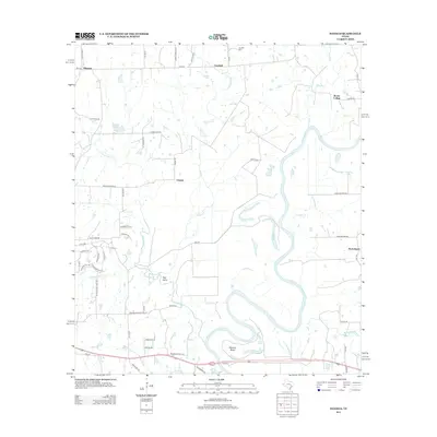
2013 Map of Daniels
USGS Topo · Published 2013About this map
The Brazos River creates a meandering natural boundary across this landscape, defining the topography with its deep curves and the prominent Mexican Bend to the south. This area of Washington County is characterized by a network of rural settlements and agricultural routes, where small communities like Goodwill and Whitman sit along the northern corridor near Franklin Cem. The map reveals a transition between established homesteads and the river's floodplain, marked by numerous drainage features such as New Year Cr, Jackson Cr, and Red Gully.
Find a feature on this map
62 named features on this map. Tap any name to fly to it.
Don’t see what you’re looking for? This feature index may not catch every label — zoom into the map to look around manually.
Map Details
Editions of this 2013 Daniels Map
This is the sole edition of this map. No revisions or reprints were ever made.
Other maps of this area

1914 · Gay Hill
USGS Topo · 1:62,500

1914 · Navasota
USGS Topo · 1:62,500

1930 · Brenham
USGS Topo · 1:62,500

1954 · Austin
USGS Topo · 1:250,000

1956 · Hempstead
USGS Topo · 1:62,500

1956 · Brenham
USGS Topo · 1:62,500

1958 · Washington
USGS Topo · 1:24,000

1958 · Courtney
USGS Topo · 1:24,000

1959 · Independence
USGS Topo · 1:24,000
1961 · Hempstead
USGS Topo · 1:24,000