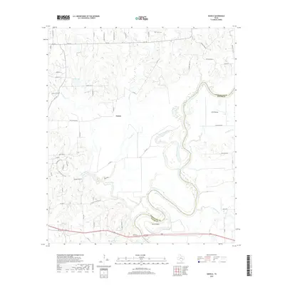
2019 Map of Daniels
USGS Topo · Published 2019About this map
The Brazos River creates a meandering border between Washington and Waller Counties, carving a distinctive landscape defined by significant alluvial features like Mexican Bend and Clark Bottom. The settlement of Daniels sits centrally among a network of rural routes, including Old Plantation Rd and Old Stagecoach Rd, which hint at the historical travel patterns through this part of East Texas. Genealogists may find interest in the Franklin Cem located in the northern portion of the quadrangle. The hydrology of the area is particularly complex, with numerous drainages such as New Year Creek, Walnut Bayou, and Jackson Cr feeding into the main river system. Notable water bodies like Hughes Lake and the smaller Clark Lake further define the terrain, which is largely shaped by the erosive force of these varied waterways.
Find a feature on this map
60 named features on this map. Tap any name to fly to it.
Don’t see what you’re looking for? This feature index may not catch every label — zoom into the map to look around manually.
Map Details
Editions of this 2019 Daniels Map
This is the sole edition of this map. No revisions or reprints were ever made.
Other maps of this area

1914 · Gay Hill
USGS Topo · 1:62,500

1914 · Navasota
USGS Topo · 1:62,500

1930 · Brenham
USGS Topo · 1:62,500

1954 · Austin
USGS Topo · 1:250,000

1956 · Hempstead
USGS Topo · 1:62,500

1956 · Brenham
USGS Topo · 1:62,500

1958 · Washington
USGS Topo · 1:24,000

1958 · Courtney
USGS Topo · 1:24,000

1959 · Independence
USGS Topo · 1:24,000
1961 · Hempstead
USGS Topo · 1:24,000