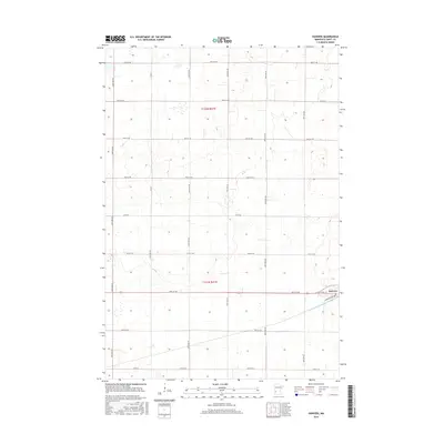
2016 Map of Danvers
USGS Topo · Published 2016About this map
The small community of Danvers serves as the focal point of this Swift County landscape, situated where the grid of rural township roads meets the more concentrated residential streets of Minnesota Ave and Maryland Ave. A central Po marks the village's role as a local service hub for the surrounding agricultural tracts. The terrain is defined by a strictly organized section-line road network, including thoroughfares such as Co Rd 11 and Co Rd 56, which facilitate the movement of goods across the prairie. Water management is a critical aspect of this environment, evidenced by the engineered path of Judicial Ditch Number Eighty flowing southeast of the main settlement. This infrastructure reflects the long-term transformation of the region's hydrology to support intensive farming, showing how natural drainage has been systematically modified to maintain the productive capacity of the soil.
Find a feature on this map
30 named features on this map. Tap any name to fly to it.
Don’t see what you’re looking for? This feature index may not catch every label — zoom into the map to look around manually.
Map Details
Editions of this 2016 Danvers Map
This is the sole edition of this map. No revisions or reprints were ever made.
Other maps of this area

1953 · Saint Cloud
USGS Topo · 1:250,000

1957 · Saint Cloud
USGS Topo · 1:250,000

1958 · Saint Cloud
USGS Topo · 1:250,000

1958 · Big Bend City
USGS Topo · 1:24,000

1958 · Milan NW
USGS Topo · 1:24,000

1958 · Gracelock NW
USGS Topo · 1:24,000

1968 · Danvers
USGS Topo · 1:24,000

1968 · Hancock
USGS Topo · 1:24,000
1968 · Hancock SW
USGS Topo · 1:24,000
1968 · Clontarf North
USGS Topo · 1:24,000