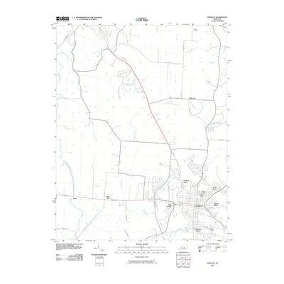
2010 Map of Danville
USGS Topo · Published 2010About this map
Danville serves as the focal point of this Central Kentucky landscape, showing the city's residential and commercial expansion at the start of the 21st century. The map details several distinct neighborhoods and developments, including Caldwell Manor, Green Acres, and Baughman Heights, reflecting the suburban growth surrounding the historical core. Significant local heritage is preserved in the numerous burial grounds documented here, most notably the Danville National Cemetery and Bellevue Cemetery, alongside outlying sites like Burgin Cemetery. The natural geography is defined by the winding course of the Salt River to the west and the various tributaries such as Mocks Branch and Clarks Run that drain the undulating terrain. To the north and west, smaller settlements and named elevations like Faulconer, Atoka, and Davis Hill mark the transition into the agricultural and rural stretches of the county.
Find a feature on this map
43 named features on this map. Tap any name to fly to it.
Don’t see what you’re looking for? This feature index may not catch every label — zoom into the map to look around manually.
Map Details
Editions of this 2010 Danville Map
This is the sole edition of this map. No revisions or reprints were ever made.
Other maps of this area

1905 · Harrodsburg
USGS Topo · 1:125,000

1950 · Bryantsville
USGS Topo · 1:24,000

1952 · Perryville
USGS Topo · 1:24,000

1952 · Danville
USGS Topo · 1:24,000

1952 · Harrodsburg
USGS Topo · 1:24,000

1952 · Cornishville
USGS Topo · 1:24,000

1952 · Bryantsville
USGS Topo · 1:24,000

1952 · Stanford
USGS Topo · 1:24,000
1952 · Wilmore
USGS Topo · 1:24,000

1952 · Junction City
USGS Topo · 1:24,000