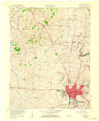
1959 Map of Danville
USGS Topo · Published 1960About this map
Danville serves as the focal point of this 1959 revision, showing the city's mid-century expansion through neighborhoods like Caldwell Manor and Green Acres. The presence of Centre College and the State School for the Deaf anchors the urban core, while the Southern railroad line facilitates the local economy. To the west, the landscape transitions into the agricultural reaches of the Salt River valley, where historic rural markers like the Mud Meetinghouse and Salt River Cemetery indicate long-standing community roots.
Find a feature on this map
58 named features on this map. Tap any name to fly to it.
Don’t see what you’re looking for? This feature index may not catch every label — zoom into the map to look around manually.
Map Details
Editions of this 1959 Danville Map
This is the sole edition of this map. No revisions or reprints were ever made.
Other maps of this area

1905 · Harrodsburg
USGS Topo · 1:125,000

1950 · Bryantsville
USGS Topo · 1:24,000

1952 · Perryville
USGS Topo · 1:24,000

1952 · Danville
USGS Topo · 1:24,000

1952 · Harrodsburg
USGS Topo · 1:24,000

1952 · Cornishville
USGS Topo · 1:24,000

1952 · Bryantsville
USGS Topo · 1:24,000

1952 · Stanford
USGS Topo · 1:24,000
1952 · Wilmore
USGS Topo · 1:24,000

1952 · Junction City
USGS Topo · 1:24,000