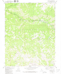
1979 Map of Dardanelle
USGS Topo · Published 1979About this map
The Middle Fork Stanislaus River carves through the heart of the Stanislaus National Forest, defining a landscape of high-elevation meadows and peaks in the late 1970s. The settlement at Dardanelle and the outpost at Baker Station serve as primary human markers along the river corridor, while higher elevations are characterized by numerous meadows such as Sardine Meadow, Eagle Meadow, and Castle Meadow.
Find a feature on this map
45 named features on this map. Tap any name to fly to it.
Don’t see what you’re looking for? This feature index may not catch every label — zoom into the map to look around manually.
Map Details
Editions of this 1979 Dardanelle Map
3 editions found
Other maps of this area

1896 · Dardanelles
USGS Topo · 1:125,000

1898 · Dardanelles
USGS Topo · 1:125,000

1948 · Walker Lake
USGS Topo · 1:250,000

1956 · Dardanelles Cone
USGS Topo · 1:62,500

1956 · Pinecrest
USGS Topo · 1:62,500

1956 · Sonora Pass
USGS Topo · 1:62,500
1956 · Tower Peak
USGS Topo · 1:62,500

1957 · Walker Lake
USGS Topo · 1:250,000

1962 · Walker Lake
USGS Topo · 1:250,000

1964 · Walker Lake
USGS Topo · 1:250,000