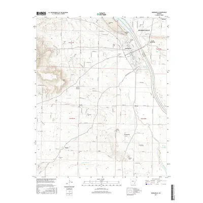
2017 Map of Dardanelle
USGS Topo · Published 2017About this map
Dardanelle Rock stands as a prominent landmark where the Arkansas River divides Yell and Pope counties. This 2017 survey details the urban centers of Dardanelle and Russellville, alongside smaller rural communities like Elberta, Prosperity, and Ard. The landscape is a study in transition, moving from the flat alluvial lands of the river basin to the rising elevations of Mt Nebo and Jones Mtn. Genealogists will find a wealth of family history sites, including the Banks Hill Family Cem, Thompson Family Cem, and the Oak Grove Methodist Church Cem. The mapping traces local hydrology through named features like Smiley Bayou, Harris Cr, and Winthrop Rockefeller Lake, reflecting the intricate water system that has long influenced settlement patterns in this central Arkansas region.
Find a feature on this map
73 named features on this map. Tap any name to fly to it.
Don’t see what you’re looking for? This feature index may not catch every label — zoom into the map to look around manually.
Map Details
Editions of this 2017 Dardanelle Map
This is the sole edition of this map. No revisions or reprints were ever made.
Other maps of this area

1888 · Dardanelle #4
USGS Topo · 1:62,500

1888 · Dardanelle #2
USGS Topo · 1:62,500

1888 · Dardanelle #1
USGS Topo · 1:62,500

1888 · Dardanelle #3
USGS Topo · 1:62,500

1890 · Dardanelle
USGS Topo · 1:125,000

1956 · Russellville
USGS Topo · 1:250,000
1962 · Russellville East
USGS Topo · 1:24,000

1962 · Delaware
USGS Topo · 1:24,000
1963 · Russellville West
USGS Topo · 1:24,000

1964 · Russellville
USGS Topo · 1:250,000