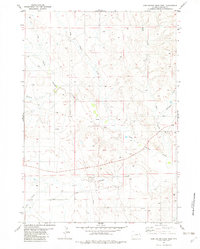
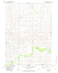
1982 Map of Darlington Draw West
USGS Topo · Published 1982About this map
Black Thunder Creek and its many tributaries, including Buzzard Creek and Prairie Creek, define the landscape of this Weston County region in the early 1980s. The map captures a moment of infrastructure development and rural life, featuring the Darlington Sch and several drill holes that suggest resource exploration in the area. The terrain is a network of intermittent drainage ways, with Rock Creek and Darlington Draw carving through the plains. The presence of a prominent pipeline and the established Piney Canyon Road illustrate the transition of this open range into a more managed industrial and agricultural landscape. This survey provides specific locations for researchers interested in the legacy of early school districts and the spatial layout of Wyoming's ranching and energy-producing high plains.
Find a feature on this map
16 named features on this map. Tap any name to fly to it.
Don’t see what you’re looking for? This feature index may not catch every label — zoom into the map to look around manually.
Map Details
Editions of this 1982 Darlington Draw West Map
This is the sole edition of this map. No revisions or reprints were ever made.
Other maps of this area

1955 · Newcastle
USGS Topo · 1:250,000

1958 · Newcastle
USGS Topo · 1:250,000

1971 · Piney Canyon NE
USGS Topo · 1:24,000

1971 · Piney Canyon SE
USGS Topo · 1:24,000
1971 · Buck Creek
USGS Topo · 1:24,000

1974 · Reno Junction
USGS Topo · 1:100,000

1979 · Newcastle
USGS Topo · 1:100,000
1982 · Wildlife Draw West
USGS Topo · 1:24,000
1982 · Lion Creek
USGS Topo · 1:24,000
1982 · Poddy Creek
USGS Topo · 1:24,000