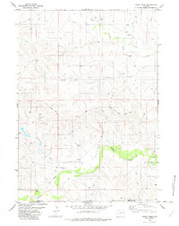
1982 Map of Poddy Creek
USGS Topo · Published 1982About this map
The Cheyenne River winds through the southern reaches of this landscape, defining the boundary between Weston and Niobrara counties. The terrain is a network of seasonal drainages and draws, such as School Draw, Dixon Draw, and Fred Draw, which feed into larger watercourses like Black Thunder Creek and Poddy Creek. This 1980s-era survey highlights the expansion of the energy industry in the Powder River Basin, evidenced by the numerous clusters of Oil Wells, Gas Wells, and storage Tanks concentrated near the Clareton Oil Field. The primary artery through this high plains region is Dull Center Road, providing access to the scattered drilling sites and cattle operations that define the local economy. Notable family-named features like Turner Creek and Owl Creek offer clues for genealogists tracing ranching history along the river breaks.
Find a feature on this map
18 named features on this map. Tap any name to fly to it.
Don’t see what you’re looking for? This feature index may not catch every label — zoom into the map to look around manually.
Map Details
Editions of this 1982 Poddy Creek Map
This is the sole edition of this map. No revisions or reprints were ever made.
Other maps of this area

1955 · Newcastle
USGS Topo · 1:250,000

1958 · Newcastle
USGS Topo · 1:250,000

1979 · Newcastle
USGS Topo · 1:100,000
1981 · Wagonhound Creek
USGS Topo · 1:24,000

1981 · Garland Draw
USGS Topo · 1:24,000

1981 · Wagonhound Creek NE
USGS Topo · 1:24,000

1981 · Lance Creek
USGS Topo · 1:100,000
1982 · Darlington Draw West
USGS Topo · 1:24,000
1982 · Lion Creek
USGS Topo · 1:24,000

1982 · Clareton
USGS Topo · 1:24,000