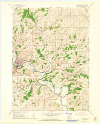
1962 Map of Darlington
USGS Topo · Published 1964About this map
Darlington serves as the focal point of this southwestern Wisconsin landscape, situated at a major bend in the Pecatonica River. In the early 1960s, the town's street grid is clearly defined, supporting a local economy tied to the river and the Chicago Milwaukee St Paul and Pacific railroad. The surrounding countryside is divided into the townships of Willow Springs, Fayette, Lamont, and Wiota, characterized by a dense network of rural one-room schoolhouses such as Willow Springs Sch, Paper Sch, and Otter Creek Sch. Numerous quarries dot the hillsides, indicating a reliance on local mineral extraction. Waterways like Otter Creek and Ames Branch cut through the terrain, while landmarks like Fayette Cem and Holy Rosary Cem provide essential anchor points for genealogists tracing families in Lafayette County during this era.
Find a feature on this map
24 named features on this map. Tap any name to fly to it.
Don’t see what you’re looking for? This feature index may not catch every label — zoom into the map to look around manually.
Map Details
Editions of this 1962 Darlington Map
This is the sole edition of this map. No revisions or reprints were ever made.
Other maps of this area

1902 · Mineral Point
USGS Topo · 1:125,000

1923 · Blanchardville
USGS Topo · 1:62,500

1923 · South Wayne
USGS Topo · 1:62,500

1952 · Shullsburg
USGS Topo · 1:24,000

1952 · Calamine
USGS Topo · 1:24,000

1952 · Mineral Point
USGS Topo · 1:24,000

1954 · Rockford
USGS Topo · 1:250,000

1955 · Rockford
USGS Topo · 1:250,000

1958 · Rockford
USGS Topo · 1:250,000

1959 · Dubuque
USGS Topo · 1:250,000