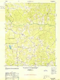
1950 Map of Darvills
USGS Topo · Published 1951About this map
Camp Pickett Military Reservation dominates the western landscape of this mid-century survey, its boundary cutting through the rural character of Dinwiddie County. The map details a transition from the structured military landscape, featuring Tommeheton Lake, to the established agricultural communities centered around the settlement of Darvills. This era shows a dense network of local social pillars, including the Darvills Community Center, Hebron School, and Hawkins Memorial Church. Numerous small creek branches, such as Cooks Branch and Turkey Egg Creek, define the topography and influenced the placement of homesteads and older crossroads like Dickerson Store. The cartography captures the persistence of small rural congregations, with Butterwood Church, Shiloh Church, and Mansons Church serving as focal points for the surrounding countryside. This survey is particularly valuable for tracing family sites and local landmarks before later 20th-century developments altered the road networks and rural density.
Find a feature on this map
28 named features on this map. Tap any name to fly to it.
Don’t see what you’re looking for? This feature index may not catch every label — zoom into the map to look around manually.
Map Details
Editions of this 1950 Darvills Map
2 editions found
Other maps of this area

1897 · Amelia
USGS Topo · 1:125,000

1918 · Lawrenceville
USGS Topo · 1:62,500

1919 · Mc Kenney
USGS Topo · 1:48,000

1920 · Lawrenceville
USGS Topo · 1:48,000

1921 · Mc Kenney
USGS Topo · 1:62,500

1921 · Lawrenceville
USGS Topo · 1:62,500

1942 · Lawrenceville
USGS Topo · 1:62,500

1943 · Mc Kenney
USGS Topo · 1:62,500

1943 · De Witt
USGS Topo · 1:24,000

1943 · Church Road
USGS Topo · 1:24,000