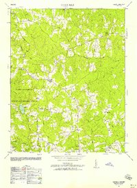
1950 Map of Darvills
USGS Topo · Published 1958About this map
The settlement of Darvills serves as a central point in this rural Dinwiddie County landscape during the early 1950s. This survey, revised by the Army Map Service, captures the extensive footprint of the Camp Pickett Military Reservation occupying the southwestern portion of the sheet. The landscape is defined by its social and educational infrastructure, featuring numerous country churches like Butterwood Church, Sharon Church, and Good Shepherd Church, alongside local landmarks such as Dickerson Store and the Darvills Community Center.
Find a feature on this map
26 named features on this map. Tap any name to fly to it.
Don’t see what you’re looking for? This feature index may not catch every label — zoom into the map to look around manually.
Map Details
Editions of this 1950 Darvills Map
2 editions found
Other maps of this area

1897 · Amelia
USGS Topo · 1:125,000

1918 · Lawrenceville
USGS Topo · 1:62,500

1919 · Mc Kenney
USGS Topo · 1:48,000

1920 · Lawrenceville
USGS Topo · 1:48,000

1921 · Mc Kenney
USGS Topo · 1:62,500

1921 · Lawrenceville
USGS Topo · 1:62,500

1942 · Lawrenceville
USGS Topo · 1:62,500

1943 · Mc Kenney
USGS Topo · 1:62,500

1943 · De Witt
USGS Topo · 1:24,000

1943 · Church Road
USGS Topo · 1:24,000