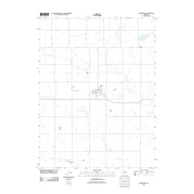
2011 Map of Davenport
USGS Topo · Published 2011About this map
Davenport serves as the central hub of this Thayer County landscape, where the grid of rural roads meets the branching hydrology of the Sandy Creek system. The map reveals a land defined by water management and local aviation, with several small-scale water control structures including Jennings Dam, Jagels Dam, and Schroeder Dam, the latter of which creates the Schroeder Reservoir in the southern portion of the quadrangle. Transport and infrastructure are localized, featuring the Davenport Post Office and two private landing strips, Grone Airport and the R and R Farms Airport, which suggest the importance of aerial access in this agricultural region. The drainage patterns of Big Sandy Creek and Little Sandy Creek dictate the placement of farmsteads and the orientation of secondary routes like W Co Rd and S Aspen Ave.
Find a feature on this map
23 named features on this map. Tap any name to fly to it.
Don’t see what you’re looking for? This feature index may not catch every label — zoom into the map to look around manually.
Map Details
Editions of this 2011 Davenport Map
This is the sole edition of this map. No revisions or reprints were ever made.
Other maps of this area

1898 · Hebron
USGS Topo · 1:125,000

1955 · Lincoln
USGS Topo · 1:250,000

1957 · Lincoln
USGS Topo · 1:250,000

1958 · Lincoln
USGS Topo · 1:250,000

1960 · Edgar
USGS Topo · 1:24,000

1960 · Davenport
USGS Topo · 1:24,000
1960 · Oak
USGS Topo · 1:24,000

1960 · Carleton
USGS Topo · 1:24,000
1960 · Ruskin
USGS Topo · 1:24,000
1960 · Deshler
USGS Topo · 1:24,000