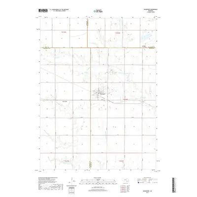
2017 Map of Davenport
USGS Topo · Published 2017About this map
Davenport serves as the central hub of this agricultural landscape in south-central Nebraska, situated at the convergence of several county roads including South St and N Linden Ave. The surrounding terrain is defined by the drainage network of the Big Sandy Cr and its tributaries, which have carved modest valleys across the prairie. Small-scale water management is evident through features like Jennings Reservoir and Schroeder Reservoir, reflecting the essential relationship between the local geography and the region's farming heritage. Near the northern boundary, the settlement of Carlisle sits along the Fillmore and Thayer County line. This 2017 survey documents the enduring grid system of rural roads, such as Rd AA and Rd 5000, which provide access to the expansive sections that have historically supported the area's agrarian economy.
Find a feature on this map
44 named features on this map. Tap any name to fly to it.
Don’t see what you’re looking for? This feature index may not catch every label — zoom into the map to look around manually.
Map Details
Editions of this 2017 Davenport Map
This is the sole edition of this map. No revisions or reprints were ever made.
Other maps of this area

1898 · Hebron
USGS Topo · 1:125,000

1955 · Lincoln
USGS Topo · 1:250,000

1957 · Lincoln
USGS Topo · 1:250,000

1958 · Lincoln
USGS Topo · 1:250,000

1960 · Edgar
USGS Topo · 1:24,000

1960 · Davenport
USGS Topo · 1:24,000
1960 · Oak
USGS Topo · 1:24,000

1960 · Carleton
USGS Topo · 1:24,000
1960 · Ruskin
USGS Topo · 1:24,000
1960 · Deshler
USGS Topo · 1:24,000