
1949 Map of Davis
USGS Topo · Published 1984About this map
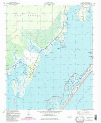
Core Sound defines the geographic character of this coastal region, separating the mainland fishing villages from the outer barrier of Core Banks. Along the western shore, the settlements of Stacy, Davis, and Sealevel follow the natural high ground between the extensive wetlands of Davis Marsh and King Point Marsh. The map reveals the intricate water-based infrastructure of the mid-20th century, including Davis Landing and numerous small creek networks like Smyrna Creek and Broad Creek. To the east, the Cape Lookout National Seashore protects a series of islands including Horse Island and Fortin Island. Local history is preserved in the locations of the Stacy School and family-named landmarks like Stacey Cemetery and Murphy Cemetery, reflecting a landscape deeply tied to the tides and the maritime economy of Carteret County.
Find a feature on this map
82 named features on this map. Tap any name to fly to it.
Don’t see what you’re looking for? This feature index may not catch every label — zoom into the map to look around manually.
Map Details
Editions of this 1949 Davis Map
2 editions found
Other maps of this area

1949 · Atlantic
USGS Topo · 1:24,000

1949 · Styron Bay
USGS Topo · 1:24,000

1949 · Long Bay
USGS Topo · 1:24,000

1949 · Williston
USGS Topo · 1:24,000

1949 · Harkers Island
USGS Topo · 1:24,000

1949 · South River
USGS Topo · 1:24,000

1950 · Horsepen Point
USGS Topo · 1:24,000

1950 · Long Bay
USGS Topo · 1:24,000

1950 · South River
USGS Topo · 1:24,000

1951 · Williston
USGS Topo · 1:24,000