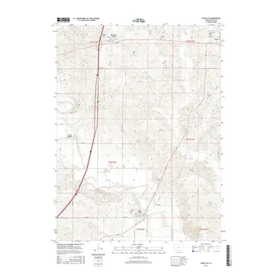
2015 Map of Davis City
USGS Topo · Published 2015About this map
Thompson River meanders southward through this Decatur County landscape, carving a valley that anchors the primary settlements of Davis City and Decatur City. This modern survey reveals a region defined by agricultural traditions and localized community hubs, where the river's drainage network, including Potteroff Cr and Britton Br, has long influenced the placement of homesteads and thoroughfares. Genealogists will find an unusually high density of burial sites for a single quadrangle, ranging from the Decatur City Cem in the north to the Davis City Cem in the south, along with several family and community grounds like Waller Cem and Gore Cem. The transportation infrastructure is anchored by Interstate 35 and Old US Hwy 69, tracing historical transit corridors between the seat at Leon and the small hamlet of Terre Haute.
Find a feature on this map
51 named features on this map. Tap any name to fly to it.
Don’t see what you’re looking for? This feature index may not catch every label — zoom into the map to look around manually.
Map Details
Editions of this 2015 Davis City Map
This is the sole edition of this map. No revisions or reprints were ever made.
Other maps of this area

1945 · Lamoni
USGS Topo · 1:62,500

1947 · Lamoni
USGS Topo · 1:62,500

1954 · Centerville
USGS Topo · 1:250,000

1957 · Centerville
USGS Topo · 1:250,000

1958 · Centerville
USGS Topo · 1:250,000

1964 · Pleasanton
USGS Topo · 1:24,000

1964 · Leon
USGS Topo · 1:24,000

1965 · Garden Grove SW
USGS Topo · 1:24,000
1981 · Van Wert
USGS Topo · 1:24,000
1981 · Lamoni South
USGS Topo · 1:24,000