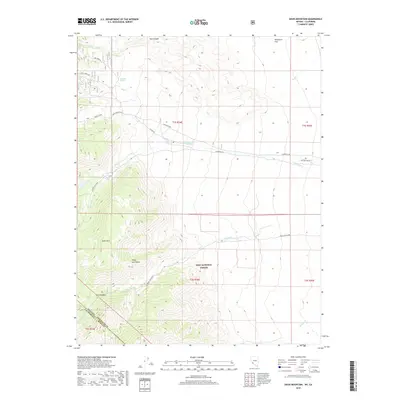
2018 Map of Davis Mountain
USGS Topo · Published 2018About this map
Davis Mtn and the high desert terrain of the White-Inyo Range dominate this landscape along the Nevada and California border. In the late 2010s, this region of Esmeralda County remained a sparsely populated wilderness, characterized by steep canyons and seasonal waterways. Historically significant routes like B&B Mine Rd and Indian Creek Road provide access to the interior of the Inyo National Forest, suggesting a legacy of resource extraction and rugged navigation. Drainage patterns are clearly defined by the paths of Chiatovich Cr and Middle Creek, while features like Sagehen Spring and Post Meadow highlight the critical role of water sources in this arid environment. The map captures the transition between high mountain peaks and lower elevations like Wildhorse Flat, providing a precise record of the natural topography.
Find a feature on this map
29 named features on this map. Tap any name to fly to it.
Don’t see what you’re looking for? This feature index may not catch every label — zoom into the map to look around manually.
Map Details
Editions of this 2018 Davis Mountain Map
This is the sole edition of this map. No revisions or reprints were ever made.
Other maps of this area

1917 · White Mountain
USGS Topo · 1:125,000

1947 · Mariposa
USGS Topo · 1:250,000

1948 · Mariposa
USGS Topo · 1:250,000

1957 · Mariposa
USGS Topo · 1:250,000

1962 · Benton
USGS Topo · 1:62,500

1962 · Mt. Barcroft
USGS Topo · 1:62,500

1962 · White Mtn. Peak
USGS Topo · 1:62,500

1963 · Mariposa
USGS Topo · 1:250,000

1963 · Davis Mountain
USGS Topo · 1:62,500
1987 · Volcanic Hills West
USGS Topo · 1:24,000