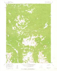
1955 Map of Davis Peak
USGS Topo · Published 1963About this map
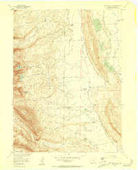
Continental Divide serpentines through this high-altitude landscape of the Sierra Madre Park Range during the mid-1950s. The area is defined by massive peaks including Davis Peak and Buck Mtn, set within the protected boundaries of the Routt National Forest. A network of historic transportation routes for both livestock and recreation is visible, featuring the Stock Driveway and the Stump Park Trail. Water sources are abundant in this alpine environment, from the headwaters of the Encampment River to high-elevation basins like Seven Lakes and Lake Eileen. The map provides a detailed view of the drainage patterns for Damfino Creek and Big Creek, illustrating how the seasonal snowmelt feeds these waterways across the Jackson and Routt county line.
Find a feature on this map
27 named features on this map. Tap any name to fly to it.
Don’t see what you’re looking for? This feature index may not catch every label — zoom into the map to look around manually.
Map Details
Editions of this 1955 Davis Peak Map
5 editions found
Other maps of this area

1911 · Hahns Peak
USGS Topo · 1:125,000

1913 · Hahns Peak
USGS Topo · 1:125,000

1939 · Saratoga
USGS Topo · 1:125,000

1954 · Rawlins
USGS Topo · 1:250,000

1954 · Craig
USGS Topo · 1:250,000

1955 · Davis Peak
USGS Topo · 1:24,000

1955 · Mount Zirkel
USGS Topo · 1:24,000

1955 · Pearl
USGS Topo · 1:24,000
1956 · Boettcher Lake
USGS Topo · 1:24,000

1956 · Pearl
USGS Topo · 1:62,500