
1916 Map of Davis
USGS Topo · Published 1916About this map
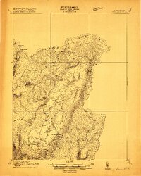
The Fairfax Stone marks the historical starting point for this 1916 survey, a crucial monument defining the boundary between Maryland and West Virginia. This region of the Allegheny plateau is defined by the winding Blackwater River and its numerous tributaries, including Pendleton Creek and Beaver Creek. The landscape reveals a burgeoning industrial economy driven by timber and coal, with the W MD RR and extensive Lumber RR lines threading through the valley to serve the established centers of Thomas and Davis.
Find a feature on this map
44 named features on this map. Tap any name to fly to it.
Don’t see what you’re looking for? This feature index may not catch every label — zoom into the map to look around manually.
Map Details
Editions of this 1916 Davis Map
2 editions found
Other maps of this area

1886 · St. George
USGS Topo · 1:125,000

1889 · Beverly
USGS Topo · 1:125,000

1891 · St. George
USGS Topo · 1:125,000

1892 · Beverly
USGS Topo · 1:125,000

1892 · Franklin
USGS Topo · 1:125,000

1895 · Piedmont
USGS Topo · 1:125,000

1896 · Franklin
USGS Topo · 1:125,000

1899 · Oakland
USGS Topo · 1:62,500

1900 · Oakland
USGS Topo · 1:62,500

1907 · Kingwood
USGS Topo · 1:62,500