
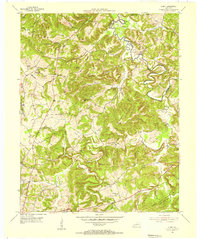
1953 Map of Dawson Springs SW
USGS Topo · Published 1954About this map
Pennyrile State Forest dominates the eastern half of this landscape, where the Tradewater River and its many tributaries, including Clifty Creek and Piny Creek, carve a series of deep hollows like Sheephole Hollow. In the early 1950s, this area of Caldwell and Christian Counties remained largely rural, defined by a network of country churches and family burial grounds. Notable landmarks include Woods Chapel and the Lookout Tower, alongside a scattering of small communities such as Hawkins and Claxton Crossroads. The western section shows a shift toward agricultural land use, punctuated by the path of the Illinois Central railroad and a designated Game Refuge. Genealogists will find significant value in the documentation of several family-named cemeteries, such as Vanhooser Cem, Hart Cem, and Newson Cem, which provide a clear record of the local population during this mid-century period.
Find a feature on this map
37 named features on this map. Tap any name to fly to it.
Don’t see what you’re looking for? This feature index may not catch every label — zoom into the map to look around manually.
Map Details
Editions of this 1953 Dawson Springs SW Map
This is the sole edition of this map. No revisions or reprints were ever made.
Other maps of this area

1908 · Princeton
USGS Topo · 1:62,500

1909 · Dawson Springs
USGS Topo · 1:48,000

1910 · Princeton
USGS Topo · 1:62,500

1911 · Dawson Springs
USGS Topo · 1:62,500

1952 · Pleasant Green Hill
USGS Topo · 1:24,000

1953 · Dawson Springs SE
USGS Topo · 1:24,000

1953 · Gracey
USGS Topo · 1:24,000

1953 · Cobb
USGS Topo · 1:24,000

1954 · Evansville
USGS Topo · 1:250,000
1954 · Olney
USGS Topo · 1:24,000