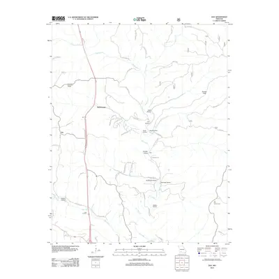
2012 Map of Day
USGS Topo · Published 2012About this map
Bull Creek and its many winding tributaries, including Woods Fork and Bear Creek, define the topography of this portion of Taney County. The landscape is characterized by a dense network of ridges and hollows, such as Chestnut Ridge and Beachler Ridge, which have influenced local settlement patterns and the winding routes of roads like Logan Ridge Rd. The small community of Day and the newer development of Saddlebrooke sit near these watercourses, while family names are preserved in features like Nash Cemetery and the many named hollows. Historical utility and conservation efforts are evident through the presence of the Hill Top Lookout Tower and natural landmarks like Dewitt Cave. The map reflects a rural Missouri landscape where modern residential planning in Saddlebrooke meets the traditional agricultural and topographic divisions of the Ozark hills.
Find a feature on this map
64 named features on this map. Tap any name to fly to it.
Don’t see what you’re looking for? This feature index may not catch every label — zoom into the map to look around manually.
Map Details
Editions of this 2012 Day Map
This is the sole edition of this map. No revisions or reprints were ever made.
Other maps of this area

1907 · Forsyth
USGS Topo · 1:125,000

1945 · Harrison
USGS Topo · 1:250,000

1949 · Harrison
USGS Topo · 1:250,000

1950 · Garber
USGS Topo · 1:24,000

1954 · Harrison
USGS Topo · 1:250,000

1955 · Garrison
USGS Topo · 1:24,000
1955 · Selmore
USGS Topo · 1:24,000
1955 · Chadwick
USGS Topo · 1:24,000

1955 · Day
USGS Topo · 1:24,000
1955 · Highlandville
USGS Topo · 1:24,000