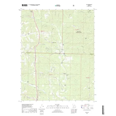
2017 Map of Day
USGS Topo · Published 2017About this map
Saddlebrooke and the small community of Day anchor this portion of the Ozark Plateau, where the boundary of Mark Twain National Forest meets private lands along the border of Christian and Taney Counties. The landscape is defined by a dense network of ridges and hollows, including Green Mound Ridge and Chestnut Ridge, which dictate the winding paths of rural roads like State Hwy BB. Genealogy researchers can locate the Nash Cem situated south of the confluence where Woods Fork and other tributaries feed into Bull Cr. The map details numerous named drainage features such as Gravelly Hollow, Tantrough Hollow, and Mathis Hollow, illustrating how the deeply dissected terrain has historically influenced settlement patterns and land use in this rugged corner of Missouri.
Find a feature on this map
91 named features on this map. Tap any name to fly to it.
Don’t see what you’re looking for? This feature index may not catch every label — zoom into the map to look around manually.
Map Details
Editions of this 2017 Day Map
This is the sole edition of this map. No revisions or reprints were ever made.
Other maps of this area

1907 · Forsyth
USGS Topo · 1:125,000

1945 · Harrison
USGS Topo · 1:250,000

1949 · Harrison
USGS Topo · 1:250,000

1950 · Garber
USGS Topo · 1:24,000

1954 · Harrison
USGS Topo · 1:250,000

1955 · Garrison
USGS Topo · 1:24,000
1955 · Selmore
USGS Topo · 1:24,000
1955 · Chadwick
USGS Topo · 1:24,000

1955 · Day
USGS Topo · 1:24,000
1955 · Highlandville
USGS Topo · 1:24,000