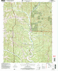
2004 Map of Day
USGS Topo · Published 2006About this map
Bull Creek and Woods Fork carve through the Ozark plateau of the Mark Twain National Forest, defining a landscape of narrow hollows and high ridges at the border of Taney and Christian counties. This 2004 revision reflects a rural community anchored by historic congregations and family sites, such as Oak Ridge Ch, New Haven Ch, and Nash Cem. The settlement of Day sits west of the main creek valley, while the terrain is marked by prominent high points like Chestnut Ridge and Round Mountain. The map illustrates the region's dual nature as both a quiet residential area and a recreational destination, featuring the Chadwick Motorcycle and ATV Use Area in the northeast. Small, local landmarks like Dewitt Cave and Anderson Cave are noted among the many hollows, including Cook Hollow and Goodnight Hollow, providing precise detail for local history research.
Find a feature on this map
39 named features on this map. Tap any name to fly to it.
Don’t see what you’re looking for? This feature index may not catch every label — zoom into the map to look around manually.
Map Details
Editions of this 2004 Day Map
This is the sole edition of this map. No revisions or reprints were ever made.
Other maps of this area

1907 · Forsyth
USGS Topo · 1:125,000

1945 · Harrison
USGS Topo · 1:250,000

1949 · Harrison
USGS Topo · 1:250,000

1950 · Garber
USGS Topo · 1:24,000

1954 · Harrison
USGS Topo · 1:250,000

1955 · Garrison
USGS Topo · 1:24,000
1955 · Selmore
USGS Topo · 1:24,000
1955 · Chadwick
USGS Topo · 1:24,000

1955 · Day
USGS Topo · 1:24,000
1955 · Highlandville
USGS Topo · 1:24,000