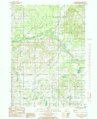
1985 Map of Dayton Center
USGS Topo · Published 1985About this map
The Manistee National Forest dominates the northern half of this 1980s landscape, where the White River and its South Branch White River meander through a densely wooded terrain. This region is defined by its transition from the managed timberlands of the forest to the agricultural and residential pockets in the townships of Denver, Dayton, and Sherman. Small settlements like Huber and Aetna anchor the rural landscape, while Dayton Center sits near the southern edge among a cluster of glacial lakes including Clarks Lake, Dutch Lake, and Devils Lake. Transportation through this part of Newaygo County is highlighted by the path of the Chesapeake and Ohio Railroad, which cuts through the northwest corner near a localized Gravel Pit. Numerous named waterways such as Martin Creek, Mena Creek, and Black Creek underscore the complex drainage patterns of this mid-Michigan watershed.
Find a feature on this map
26 named features on this map. Tap any name to fly to it.
Don’t see what you’re looking for? This feature index may not catch every label — zoom into the map to look around manually.
Map Details
Editions of this 1985 Dayton Center Map
This is the sole edition of this map. No revisions or reprints were ever made.
Other maps of this area

1931 · Walkerville NE
USGS Topo · 1:31,680

1931 · Walkerville SE
USGS Topo · 1:31,680

1954 · Milwaukee
USGS Topo · 1:250,000

1954 · Midland
USGS Topo · 1:250,000

1958 · Midland
USGS Topo · 1:250,000

1958 · Milwaukee
USGS Topo · 1:250,000

1958 · Hesperia
USGS Topo · 1:62,500

1958 · Twin Lake
USGS Topo · 1:62,500

1958 · Fremont
USGS Topo · 1:62,500

1959 · Midland
USGS Topo · 1:250,000