
1958 Map of Fremont
USGS Topo · Published 1960About this map
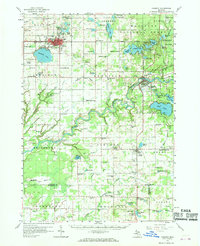
The Muskegon River snakes through the heart of this West Michigan landscape, anchoring a region defined by its numerous glacial lakes and rural schoolhouses. In the late 1950s, the city of Fremont serves as a primary hub, situated just north of Fremont Lake and served by the Chesapeake and Ohio railroad. The map reveals an extensive network of country education, with small schools like Van Korlaar Sch, Patterson Sch, and Wheat Sch spaced regularly across the agricultural townships of Sheridan and Ashland. To the northeast, the Manistee National Forest provides a more wooded character, dotted with smaller water bodies such as Sylvan Lake and Emerald Lake. This survey captures the area just before significant modernization, showing a patchwork of family cemeteries like Shippy Cem and localized industrial sites including numerous Gravel Pits that supported the local infrastructure.
Find a feature on this map
121 named features on this map. Tap any name to fly to it.
Don’t see what you’re looking for? This feature index may not catch every label — zoom into the map to look around manually.
Map Details
Editions of this 1958 Fremont Map
2 editions found
Other maps of this area

1918 · Cedar Springs
USGS Topo · 1:62,500

1930 · Muskegon
USGS Topo · 1:62,500

1931 · Walkerville SE
USGS Topo · 1:31,680

1936 · Muskegon
USGS Topo · 1:62,500

1943 · Cedar Springs
USGS Topo · 1:62,500

1945 · Ravenna
USGS Topo · 1:62,500

1954 · Milwaukee
USGS Topo · 1:250,000

1954 · Midland
USGS Topo · 1:250,000

1958 · Midland
USGS Topo · 1:250,000

1958 · Milwaukee
USGS Topo · 1:250,000