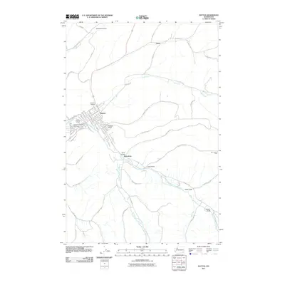
2011 Map of Dayton
USGS Topo · Published 2011About this map
Dayton serves as the primary hub of this eastern Washington landscape, situated at the confluence of several watercourses including the Touchet River and Patit Creek. The town's layout is well-defined, featuring landmarks such as the Dayton and Columbia County Fairgrounds and the Touchet Valley Golf Course. Beyond the municipal borders, the terrain is shaped by a series of geographic "hollows" and gulches, including Whetstone Hollow, Johnson Hollow, and Mustard Hollow, which illustrate how the valley floor and rising slopes have historically influenced settlement and transport. Small outlying points like Baileysburg and Ronan mark the transition from town to more dispersed land use. The presence of the Thorn Lookout Tower on the eastern edge emphasizes the prominence of the surrounding ridges. This survey details the complex network of agricultural and mountain roads, such as Harting Grade and Kendall Skyline Rd, that navigate the ridgelines and water-carved valleys of Columbia County.
Find a feature on this map
77 named features on this map. Tap any name to fly to it.
Don’t see what you’re looking for? This feature index may not catch every label — zoom into the map to look around manually.
Map Details
Editions of this 2011 Dayton Map
This is the sole edition of this map. No revisions or reprints were ever made.
Other maps of this area

1919 · Walla Walla
USGS Topo · 1:125,000

1921 · Walla Walla
USGS Topo · 1:125,000

1937 · Pomeroy
USGS Topo · 1:96,000

1942 · Pomeroy
USGS Topo · 1:125,000

1953 · Walla Walla
USGS Topo · 1:250,000

1955 · Pullman
USGS Topo · 1:250,000

1958 · Pullman
USGS Topo · 1:250,000

1958 · Walla Walla
USGS Topo · 1:250,000
1966 · Coppei
USGS Topo · 1:24,000
1967 · Robinette Mtn.
USGS Topo · 1:24,000